
- Symbols
- Natural Environment
- History
- Population and HouseHolds
- Administrative Districts
- Major Statistics
- Address of Cities/Counties
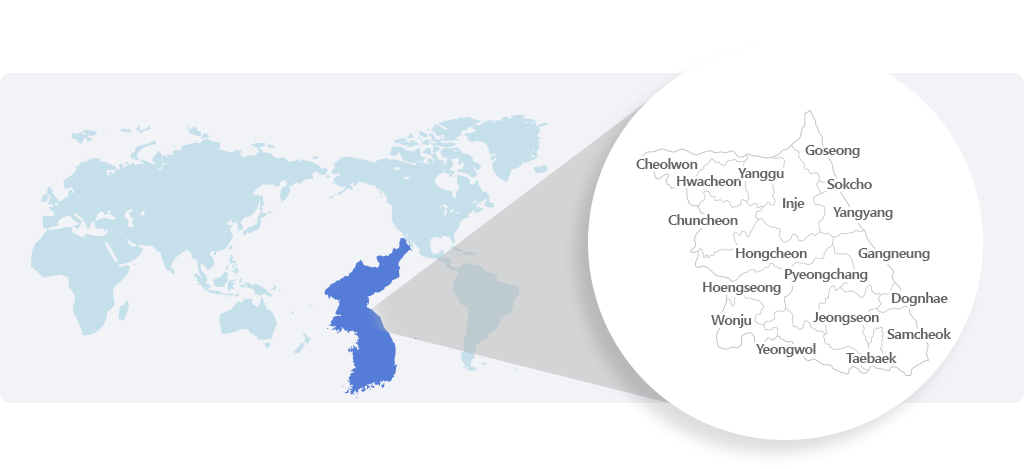
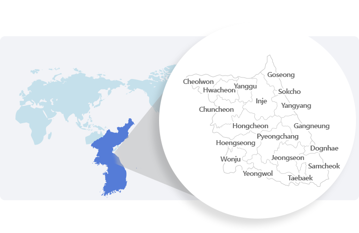
Location of Gangwon State

Gangwon State is located in the mid-eastern part of the Korean Peninsula and is divided into two areas,
Yeongdong and Yeongseo, by the Taebaek Mountains running along the eastern part of the peninsula.
It extends between 37°02' and 38°37' north latitude and 127°05' and 129°22' east longitude,
and the 38th Parallel crosses the middle of the province. The province is also crossed by the 145-km-long Military Demarcation Line (MDL),
which starts at 38°45' north latitude, in Hyeonnae-myeon in Goseong-gun to the southwest,
to a site at 38°20' north latitude linking Hyangnobong Peak, Mondong-ri and Gimhwa-eup. Gangwon State is 150 km wide,
from east to west, and 243 km long, from north to south, and has an eastern coastline of about 314 km.
The province is bordered by five provinces, three cities and 13 counties,
including Singye-gun and Gimcheon-gun in Hwanghae-do; Yeoncheon, Pocheon, Gapyeong,
Yangpyeong and Yeoju in Gyeonggi-do in the east; Chungju-si, Jecheon-si and Danyang-gun in Chungcheongbuk-do and Yeongju-si,
Bonghwa-gun and Uljin-gun in Gyeongsangbuk-do in the south;
and Anbyeon-gun and Deogwon-gun in Hamgyeongnam-do and Goksan-gun in Hwanghae-do in the north.
Area of Gangwon State
The total area of Gangwon State is 20,569Km² of which the area south of the MDL is 16,873.51㎢ ,
which accounts for 82% of the province's total area and 16.8% of the national territory of South Korea.
The total area of Gangwon State is 20,569Km² of which the area south of the MDL is 16,873.51㎢ ,
which accounts for 82% of the province's total area and 16.8% of the national territory of South Korea.
The province consists of the mountainous areas covering 81.0% of the total provincial area, including 13,665.66Km² and farming fields of 1,668.69Km²,
which accounts for 9.9%, and land for other purposes covering 9.1% of the total area, with 1,539.25Km².
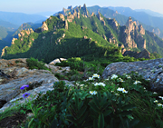
Geographical Features of Gangwon State
Gangwon State is a mountainous province, (a much greater part is occupied by mountains)and is usually divided into two areas,
Yeongdong and Yeongseo, with the Taebaek Mountains, which form the backbone of the Korean Peninsula, in the middle.
The area east of the Taebaek Mountains is marked by steep slopes with few coastal plains,
while the western area is marked by gentle slopes and mountains containing the headwaters of some of Korea's largest rivers, such as the Namhan and Bukhan Rivers.
The percentage of low land (less than 100 meters high) covers only 5.6% of the total area of Gangwon State,
which is even lower than that of Hamgyeongnam-do where the figure is 9.6%. Low hills between 100-500 meters in height cover 43.1%;
mid-height land between 500-1,000 meters covers 43.4%, a larger figure than for all the other provinces in Korea; and,
finally, highlands taller than 1,000 meters cover 7.7%. Flat,
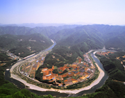
arable land for paddy cultivation is largely located along the eastern coastal area around Gangneung and Bukpyeong and is distributed around Cheorwon,
Chuncheon and Wonju in the Yeongbuk area. The northern part of the river basins feature steep valleys.
The Yeongdong area is geographically narrow due to the steep mountains facing the East Sea,
but it contains several high scenic passes, such as Daegwallyeong, Misiryeong, Jinburyeong and Hangyeryeong, and deep valleys.
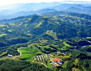
The Yeongseo area features mountains and sunken lands all running gently towards Seoul and surrounding Gyeonggi-do in the west,
and expansive highlands that offer dry fields rather than paddies and contain headwaters that flow into many streams and two of Korea's largest rivers, the Han River and Nakdong River,
that wet a large part of the Korean Peninsula. The upper streams of the Bukhan River provide habitats for various fish species,
including some of the rarest Korean native fish, and form well protected healthy ecosystems.
There are in the area several famous dams: the Peace Dam, Hwacheon Dam, Chuncheon Dam,
Soyang River Dam and Uiam Dam that supply an ample amount of water for Korean industries and daily life.
Climate of Gangwon State
Gangwon State is located in the medium-latitude temperate zone between 37° and 38° north latitude.
Located in the medium-latitude temperate zone between 37° and 38° north latitude,
Gangwon State's climate is characterized by high temperatures and humidity during the summer and coldness and dryness in the winter.
This is due to the high continental pressure which is low in temperature and humidity.
Gangwon State is geographically divided into two areas, Yeongdong and Yeongseo,
by the Taebaek Mountains as they stretch from north to south along the east of the Korean Peninsula.
Both areas feature remarkably different climatic conditions.
As for the general characteristics of the province's climate, the Yeongdong area,
in which steep mountain slopes are directly connected with the coasts, displays elements of an oceanic climate whereas the Yeongseo area,
located in the middle of the Korean Peninsula, shows characteristic elements comparable to those of a continental climate. Meanwhile,
the highlands of the Taebaek Mountains exhibit characteristic features of a mountain climate.
The Yeongdong area has a few paddy fields because of the steep mountain slopes running downwards and directly into the sea,
thus leaving only a limited area of paddy fields lying along some parts of the coastline.
Such geographical features of the area create a comparatively warmer winter and cooler summer, with a low annual temperature range.
The annual mean temperature in the Yeongdong area is higher than that of the Yeongseo area by 2° C.
The annual precipitation rates in the two areas are 2,058.5mm and 1,690.3mm,
respectively, showing that Gangwon State's eastern part, including Gangneung,
Sokcho and Samcheok, has more rainfall (by about 370 mm annually) than the western part, which includes Chuncheon, Wonju and Cheorwon.
In the winter and spring the province tends to have stronger winds than in other provinces. There is also more snow in winter.
In January and February the Yeongdong area, in particular, tends to have a much heavier snowfall than the rest of the entire country.
최근 업데이트 2023-06-11